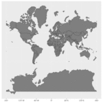
The Mercator projection vs the true size of each country.
Africa outsold
I don’t understand this ahshdhdhdh
basically maps exaggerate the landmass of most regions for aesthetic purposes
africa is the only continent that massive in reality (probably cause the Sahara is super vast); I think the conventional wisdom is that you can fit most if not all of north america within africa
What’s the real size of Africa? How Western states used maps to downplay size of continent (CNN)
“Mercator initially made globes. Later transferring his map from a three-dimensional curved surface to a flat sheet of paper was problematic. Taking the equator as the logical map center left big, confusing gaps near the poles.Mercator’s solution was to stretch out the northern and southern extremities of the globe to fill those gaps, producing an elegant and usable map.”
“[As a political tool,] one of the dangers of the Mercator map is that it can make enlarged countries seem unnaturally powerful and intimidating.”
i feel so much better knowing that all those cold ass Canadian islands are small.